


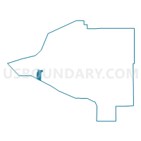
Klatt No. 1 Precinct, Anchorage Municipality, Alaska
About
Outline

Summary
| Unique Area Identifier | 523253 |
| Name | Klatt No. 1 Precinct |
| County | Anchorage Municipality |
| State | Alaska |
| Area (square miles) | 9.94 |
| Land Area (square miles) | 1.67 |
| Water Area (square miles) | 8.26 |
| % of Land Area | 16.85 |
| % of Water Area | 83.15 |
| Latitude of the Internal Point | 61.10640210 |
| Longtitude of the Internal Point | -149.91205130 |
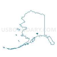
Maps

Graphs
Select a template below for downloading or customizing gragh for Klatt No. 1 Precinct, Anchorage Municipality, Alaska


Neighbors
Neighoring Voting District (by Name) Neighboring Voting District on the Map
- Bay Shore Precinct, Anchorage Municipality, AK
- Huffman No. 1 Precinct, Anchorage Municipality, AK
- Oceanview No. 1 Precinct, Anchorage Municipality, AK
- Salamatoff Precinct, Kenai Peninsula Borough, AK
- Southport Precinct, Anchorage Municipality, AK
- Sterling Precinct, Kenai Peninsula Borough, AK
Top 10 Neighboring County Subdivision (by Population) Neighboring County Subdivision on the Map
- Anchorage census subarea, Anchorage Municipality, AK (291,826)
- Kenai-Cook Inlet census subarea, Kenai Peninsula Borough, AK (49,733)
- Seward-Hope census subarea, Kenai Peninsula Borough, AK (5,667)
Top 10 Neighboring Place (by Population) Neighboring Place on the Map
Top 10 Neighboring Unified School District (by Population) Neighboring Unified School District on the Map
Top 10 Neighboring State Legislative District Lower Chamber (by Population) Neighboring State Legislative District Lower Chamber on the Map
- State House District 34, Rural Kenai, AK (18,909)
- State House District 28, Bayshore-Klatt, AK (18,473)
- State House District 31, Huffman-Ocean View, AK (17,744)
Top 10 Neighboring State Legislative District Upper Chamber (by Population) Neighboring State Legislative District Upper Chamber on the Map
- State Senate District P, AK (37,696)
- State Senate District Q, AK (37,402)
- State Senate District N, AK (36,520)
Top 10 Neighboring 111th Congressional District (by Population) Neighboring 111th Congressional District on the Map
Top 10 Neighboring Census Tract (by Population) Neighboring Census Tract on the Map
- Census Tract 27.02, Anchorage Municipality, AK (9,670)
- Census Tract 27.12, Anchorage Municipality, AK (9,068)
- Census Tract 27.11, Anchorage Municipality, AK (6,589)
- Census Tract 2, Kenai Peninsula Borough, AK (5,623)
- Census Tract 3, Kenai Peninsula Borough, AK (895)